
Zenmuse L2
LiDAR and RGB payload for survey-grade capture.
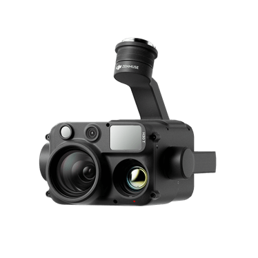
Overview
The Zenmuse L2 combines a LiDAR sensor with an RGB camera and high-accuracy IMU for corridor, forestry and terrain capture.
DRONES180 both supplies and operates LiDAR payloads, so we can advise on capture settings, ground control and deliverables.
Key capabilities
LiDAR + RGB
Colourised point clouds from a single flight.
Vegetation penetration
Ground returns beneath canopy for terrain models.
Integrated IMU
High-accuracy trajectory for point cloud quality.
Live point cloud
In-field quality checking before you leave site.
Ideal applications
Key specifications
- Sensor type
- LiDAR with integrated RGB camera
- Compatible aircraft
- DJI Matrice 350 RTK / Matrice 300 RTK
- Accuracy
- Accuracy achieved depends on flight plan, GNSS and ground control — confirmed per project
Specifications are provided as a guide from published manufacturer information and are confirmed at time of quotation.
Configuration options
DRONES180 configures the aircraft, batteries, charging and accessories around your operational requirements.
Getting Started & Support
We help you get your new drone ready for operation, with initial setup, calibration, product familiarisation and ongoing technical support. We do not provide RePL courses or accredited flight training.
Ongoing support
Commercial support does not finish at delivery — we support the aircraft through its working life.
Frequently asked questions
What accuracy can I expect?
Achievable accuracy depends on flight planning, GNSS conditions and ground control. DRONES180 will discuss realistic expectations for your project rather than quote a headline figure.
Can DRONES180 capture the data for me?
Yes. We offer LiDAR capture as a service as well as supplying the payload.